
Google-Backed FireSat Constellation Launches First Operational Satellites to Revolutionize Wildfire Detection and Global Climate Resilience

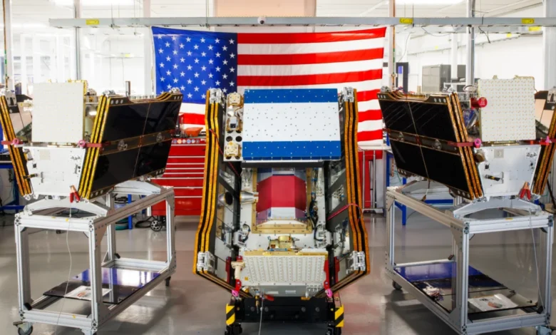
As hazardous smoke from an intensifying series of wildfires continues to blanket vast corridors of North America, the global effort to combat the climate crisis reached a significant milestone in orbit. On July 7, 2026, a SpaceX Falcon 9 rocket successfully lifted off from Vandenberg Space Force Base in California, carrying the first three operational satellites of the FireSat constellation. This deployment represents a pivotal shift in planetary monitoring, transitioning from experimental prototypes to a dedicated, high-resolution surveillance network designed specifically to identify and track wildfires at their earliest, most manageable stages. Managed by the nonprofit Earth Fire Alliance and bolstered by significant technical and financial contributions from Google and the Bezos Earth Fund, FireSat aims to fill a critical gap in existing satellite capabilities, providing firefighters with the intelligence needed to suppress "mega-fires" before they become uncontrollable.
A New Era in Space-Based Wildfire Monitoring
The launch of these three microsatellites marks the beginning of "initial operational capability" for a program that has been years in development. For decades, fire agencies have relied on multi-purpose satellites, such as NASA’s MODIS (Moderate Resolution Imaging Spectroradiometer) and VIIRS (Visible Infrared Imaging Radiometer Suite). While these instruments have been invaluable, they were designed for broad environmental monitoring and often lack the resolution or the revisit frequency required for rapid wildfire response. Traditional satellites may only pass over a specific fire-prone region once or twice a day, and their sensors often struggle to distinguish small, low-intensity ignitions from background heat or are blinded by the very smoke clouds the fires produce.
FireSat is fundamentally different. It is the world’s first satellite constellation purpose-built for wildfire detection. Each satellite is equipped with advanced multispectral imaging sensors designed by the California-based manufacturer Muon Space. These sensors are tuned to specific infrared bands that can "peer" through dense smoke and cloud cover, identifying thermal signatures with unprecedented precision. The technology allows for the detection of fires as small as five by five meters—roughly 16 by 16 feet—on the ground. This capability is a generational leap over current systems, which often require a fire to grow to the size of several football fields before it can be reliably detected from space.
Technical Specifications and the Power of Microsatellites
The success of the July launch follows a rigorous testing phase involving the FireSat Protoflight satellite, which was launched in March 2025. During its year-long trial, the Protoflight vehicle captured more than one million images, proving that microsatellites could deliver high-fidelity data previously reserved for much larger, more expensive spacecraft. By utilizing a "constellation" approach—launching dozens of smaller, cheaper satellites rather than one massive platform—the Earth Fire Alliance can ensure that no part of the Earth’s surface remains unmonitored for long.

The three new satellites will undergo a three-month commissioning and testing period to calibrate their sensors and integrate their data streams into existing emergency management frameworks. By the end of 2026, they will begin providing active data to fire agencies in the United States, Australia, and Europe. At this initial stage, the constellation will cover every fire-prone region on Earth at least twice per day. However, this is only the beginning of an aggressive scaling plan. The Earth Fire Alliance intends to launch additional batches of satellites over the next three years, aiming for hourly global coverage by 2029. By the early 2030s, when the full constellation of more than 50 satellites is in orbit, the revisit rate is expected to drop to just 20 minutes, providing near-real-time tracking of fire behavior and spread.
The Financial Landscape of the Earth Fire Alliance
The development and deployment of FireSat have been made possible through a unique public-private-philanthropic partnership. Google has been a cornerstone supporter, contributing more than $15 million in funding and substantial technical expertise through its Google Research division. The project also received a massive boost from the Bezos Earth Fund, which committed $26 million to the initiative. These investments reflect a growing recognition among tech giants and philanthropists that wildfire suppression is a critical component of global climate resilience.
For Google, the project is more than just a philanthropic endeavor; it is a showcase for the practical application of artificial intelligence. Google Research is deploying specialized AI models to process the massive influx of data from the FireSat constellation. These models compare real-time imagery with historical data and topographical maps to filter out "false positives"—such as industrial heat signatures or volcanic activity—and to predict the likely path of a blaze based on fuel loads, weather patterns, and wind speeds.
Chronology: From Concept to Global Coverage
The journey of the FireSat program illustrates the rapid acceleration of "New Space" technologies applied to environmental protection.
- 2023–2024: Conceptualization and formation of the Earth Fire Alliance. Partnerships established between Muon Space, Google, and the Bezos Earth Fund.
- March 2025: Launch of the FireSat Protoflight. The experimental satellite validates the ability to detect small-scale thermal anomalies from Low Earth Orbit (LEO).
- July 7, 2026: Launch of the first three operational satellites aboard a SpaceX Falcon 9. Transition to initial operational capability.
- Late 2026: "Early Adopter" phase begins. Fire agencies in California, Colorado, Portugal, and Australia begin integrating FireSat data into their dispatch and command systems.
- 2027–2028: Continuous launch cycle to increase the constellation size and reduce revisit times.
- 2029: Achievement of the "Hourly Revisit" milestone, providing global updates every 60 minutes.
- 2030–2032: Full constellation deployment (50+ satellites). Achieving the 20-minute revisit goal, enabling dynamic, real-time fire fighting strategies.
Combating the Carbon Feedback Loop
The environmental stakes of the FireSat mission cannot be overstated. Wildfires have become a primary driver of a "carbon feedback loop" that threatens to derail international climate goals. When forests burn, they release massive amounts of stored carbon dioxide into the atmosphere, which contributes to further global warming, which in turn creates the hot, dry conditions that lead to more frequent and intense fires.

Data from the Earth Fire Alliance suggests that the FireSat constellation could eventually prevent nearly 22 million tons of carbon emissions annually by enabling quicker suppression. Furthermore, the economic benefits are staggering; early detection is projected to save more than $1 billion in fire damage costs each year, protecting an estimated 3,500 homes and 1.3 million acres of land. In Canada alone, the 2023 and 2025 fire seasons were the most destructive on record, underscoring the urgent need for a more proactive approach to forest management.
The Role of Artificial Intelligence and the "Green" Paradox
While Google’s AI is a primary tool for making FireSat data actionable, the company’s involvement highlights a complex tension within the tech industry. The very AI models used to detect wildfires require massive amounts of electricity to train and operate. This energy demand has led to a surge in data center construction, often powered by natural gas, which could emit upwards of 129 million tons of greenhouse gases per year. Google’s own corporate sustainability reports acknowledge that its electricity usage jumped by 37 percent in 2025, driven largely by the AI boom.
Despite this paradox, the Earth Fire Alliance argues that the net benefit of AI-powered wildfire detection is overwhelmingly positive. By putting "practical AI to work for climate resilience," as Google executives described the project, the FireSat program aims to provide a tangible defense against the symptoms of a warming planet while the broader transition to clean energy continues.
Challenges in Modern Fire Suppression
Detection, however, is only half of the battle. As the current situation in Canada’s boreal forests demonstrates, even early detection cannot always stop a fire if the resources for suppression are lacking. Thousands of people in First Nations communities have been forced to evacuate this summer as fast-moving blazes outpaced local response teams. In many remote regions, fire agencies are forced to make the agonizing decision to monitor "out of control" fires rather than fight them, simply because they lack the aircraft, personnel, or water access to intervene safely.
The FireSat data will be used to help these agencies prioritize their limited resources. By identifying which small fires have the highest potential to threaten human life or critical infrastructure, commanders can deploy fixed-wing air tankers and heavy-lift helicopters more effectively. This is particularly vital as traditional fire suppression strategies are being overwhelmed by the sheer scale of modern "mega-fires" that burn with an intensity that renders ground-based firefighting impossible.

Global Early Adopters and the Path Forward
The international nature of the FireSat program is reflected in its "early adopter" cohort. Fire agencies in Portugal, a country devastated by forest fires in recent years, are working alongside departments in Australia and the Western United States to develop standardized protocols for using FireSat imagery. This global collaboration ensures that the technology is not limited to wealthy nations but can eventually be leveraged by any region facing wildfire threats.
As the smoke from the 2026 fire season continues to impact the health of over 100 million people across North America, the launch of the FireSat satellites offers a rare glimmer of technological optimism. By moving from a reactive to a proactive stance, the Earth Fire Alliance and its partners are attempting to redefine the relationship between humanity, technology, and the increasingly volatile natural world. The success of the FireSat constellation will ultimately be measured not by the number of satellites in orbit, but by the number of fires that never have the chance to grow into disasters.
Related posts: