Google-backed satellites for wildfire detection launch as smoke chokes US and Canada

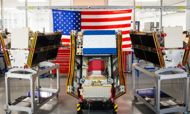
The deployment of a new vanguard in orbital fire monitoring has officially begun as three operational satellites belonging to the FireSat constellation successfully reached orbit. Launched on July 7, 2026, from the Vandenberg Space Force Base in California, these microsatellites were carried into the thermosphere aboard a SpaceX Falcon 9 rocket. This mission represents a critical milestone for the Earth Fire Alliance (EFA), a nonprofit organization coordinating a global effort to revolutionize how wildfires are detected, monitored, and suppressed. As smoke from hundreds of active blazes across the Canadian boreal forest continues to blanket major metropolitan areas in the United States and Canada, the arrival of these satellites offers a technological beacon for fire agencies currently overwhelmed by the increasing frequency and intensity of "megafires."
The FireSat program is specifically designed to address a lethal gap in current Earth-observation capabilities: the inability of existing satellites to consistently detect small, low-intensity fires before they evolve into uncontrollable infernos. Managed by the Earth Fire Alliance and built by California-based Muon Space, the constellation has garnered significant backing from major Silicon Valley players and philanthropic giants. Google has contributed over $15 million to the initiative, while the Bezos Earth Fund has committed $26 million to support the deployment and data integration of what is being hailed as the world’s first purpose-built wildfire detection constellation.
Initial Operational Capability and Technological Specifications
With the successful launch and deployment of these three satellites, the FireSat program has officially moved into its "initial operational capability" phase. Following a rigorous three-month commissioning and testing period, the satellites will begin providing high-resolution data to fire agencies across the globe. This initial trio will be capable of monitoring every fire-prone region on Earth at least twice daily. While this frequency is a starting point, the ultimate goal of the Earth Fire Alliance is to launch a full constellation of more than 50 satellites by the early 2030s, which would provide imagery updates every 20 minutes.

The technical specifications of the FireSat satellites set them apart from traditional weather or environmental monitoring platforms. Each microsatellite is equipped with advanced multispectral imaging sensors capable of peering through dense smoke and heavy cloud cover—obstacles that frequently blind standard optical satellites. Most importantly, these sensors can detect heat signatures from fires as small as five by five meters (approximately 16 by 16 feet). This resolution is a massive improvement over current public-access satellite systems like MODIS or VIIRS, which often struggle to identify small ignitions or are hampered by long gaps between orbital passes.
The efficacy of this technology was previously validated by the FireSat Protoflight satellite, which launched in March 2025. During its testing phase, the prototype collected more than one million images, demonstrating a unique ability to pinpoint low-intensity blazes that were entirely invisible to other orbital assets. This "early warning" capability is viewed by experts as the most effective way to reduce the catastrophic economic and environmental costs of wildfires.
The Economic and Environmental Stakes
The potential impact of the FireSat constellation is supported by significant data projections. According to the Earth Fire Alliance, achieving even an hourly revisit rate—slated for 2029—could lead to more than $1 billion in saved fire damage costs annually. By enabling fire crews to reach ignitions while they are still manageable, the program aims to prevent the destruction of approximately 3,500 homes and 1.3 million acres of land each year.
Beyond the immediate protection of life and property, the program serves a vital role in climate mitigation. Wildfires are a significant source of carbon emissions, creating a dangerous feedback loop where fire-driven warming leads to drier forests and more frequent fires. The Earth Fire Alliance estimates that the FireSat constellation could help prevent nearly 22 million tons of carbon emissions annually. This is particularly relevant in 2026, as Canada faces another devastating fire season. Data from the Canadian Wildland Fire Information System indicates that as of mid-July, nearly 900 fires are active across the country, with more than 6.6 million acres already scorched.

The Role of Artificial Intelligence and Big Data
A central component of the FireSat mission is the integration of Google’s artificial intelligence and machine learning models. Google Research is utilizing its proprietary AI to compare real-time data from the FireSat satellites with decades of historical satellite imagery. This process allows for the rapid identification of new heat anomalies while filtering out "false positives" such as industrial heat or controlled agricultural burns.
Google has described the project as a "tangible step forward in putting practical AI to work for climate resilience." The AI models do more than just spot fires; they are being designed to inform predictive modeling, helping fire managers understand how a specific fire might spread based on local topography, fuel loads, and current weather conditions. However, the use of AI in climate work has also invited scrutiny. Critics and industry analysts have pointed to the inherent irony in using energy-intensive AI data centers to solve climate-related problems. Google’s own reports show a 37 percent increase in electricity usage in 2025, largely driven by the expansion of AI infrastructure. This surge in energy demand often relies on natural gas projects, which could emit upwards of 129 million tons of greenhouse gases annually, potentially offsetting some of the climate gains provided by detection technologies.
A Global Network of Early Adopters
The data generated by FireSat will not be held in a vacuum. A cohort of "early adopter" organizations has already been established to integrate this information into their emergency response workflows. These include fire agencies in California and Colorado—states that have faced record-breaking wildfires over the last decade—as well as international partners in Australia and Portugal.
In Australia, where the memory of the "Black Summer" bushfires remains fresh, the ability to detect remote ignitions caused by lightning strikes is seen as a game-changer. Similarly, in Portugal, where mountainous terrain and shifting winds make ground-based detection difficult, the FireSat data will provide a much-needed "eye in the sky." By 2029, as the constellation grows, the Earth Fire Alliance intends to make this imagery available to every fire-prone nation, democratizing access to high-resolution orbital intelligence.

Chronology of the FireSat Program
- March 2025: Launch of the FireSat Protoflight satellite. This mission successfully proved that multispectral sensors could detect 5×5 meter fires and peer through heavy smoke.
- July 7, 2026: Launch of the first three operational satellites aboard a SpaceX Falcon 9.
- Late 2026: Following a 90-day testing window, fire agencies in California, Colorado, Australia, and Portugal begin using live data.
- 2027–2028: Continued launch schedule to increase the frequency of orbital passes.
- 2029: Targeted milestone for "hourly revisit" capability across the entire planet.
- Early 2030s: Completion of the full constellation (50+ satellites), providing 20-minute update intervals.
The Limits of Technology and the Crisis on the Ground
While the FireSat launch is a triumph for remote sensing, fire scientists warn that detection is only one part of a complex equation. The current crisis in Canada’s boreal forests highlights the limitations of even the best data. Many fires are currently burning in regions so remote that active suppression is logistically impossible or too dangerous for crews. In these cases, agencies are forced to monitor "out of control" fires rather than fight them, prioritizing resources for blazes that threaten human infrastructure or First Nations communities.
The intensity of modern fires, fueled by climate change, has also overwhelmed traditional fire suppression strategies. Werner Kurz, a retired senior research scientist, recently noted that as the world becomes hotter and drier, old strategies are simply being outpaced by the sheer scale of the blazes. To combat this, the Canadian government has had to expand its fleet of aerial firefighting assets, leasing 10 new aircraft this year to serve as surge capacity for provinces.
The FireSat constellation represents a significant leap forward in our ability to witness the birth of a wildfire. However, as the satellites begin their work 300 miles above the Earth, the real test will be on the ground, where fire agencies must translate this high-tech data into faster response times, more effective prescribed burns, and a more resilient approach to a warming world. The success of FireSat will ultimately be measured not by the number of images it captures, but by the number of megafires that are prevented from ever reaching their catastrophic potential.
Related posts: